Platforms: Cryosat-2
From
| Line 14: | Line 14: | ||
{| | {| | ||
|[[File:HowTo.gif|thumb|left]] | |[[File:HowTo.gif|thumb|left]] | ||
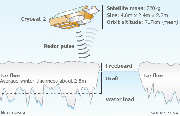
| - | | * Cryosat's radar has the resolution to see the Arctic's floes and leads | + | |{* Cryosat's radar has the resolution to see the Arctic's floes and leads |
* Some 7/8ths of the ice tends to sit below the waterline - the draft | * Some 7/8ths of the ice tends to sit below the waterline - the draft | ||
* The aim is to measure the freeboard - the ice part above the waterline | * The aim is to measure the freeboard - the ice part above the waterline | ||
| - | * Knowing this 1/8th figure allows Cryosat to work out sea ice thickness | + | * Knowing this 1/8th figure allows Cryosat to work out sea ice thickness} |
|- | |- | ||
|[[File:GravityField.jpg|thumb|left]] | |[[File:GravityField.jpg|thumb|left]] | ||
Revision as of 11:53, 3 December 2012
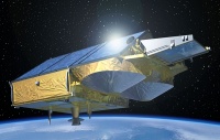
Спутник CryoSat-2 был запущен 9 апреля 2010 года с космодрома Байконур при помощи ракеты-носителя "Днепр-1". Искусственный спутник Земли Европейского космического агентства (ЕКА), предназначенный для измерения толщины и площади ледового покрова Антарктиды, Гренландии, Исландии, высокоширотных океанских зон, а также горных ледников при помощи высокоточного высотомера, способного работать в трех режимах. Спутник должен отслеживать динамику изменения ледников и прояснить вопрос о влиянии на них глобального потепления. Создан в рамках программы ЕКА «Живая планета». CrioSat-2 также предназначен для наблюдения за воздействием глобального потепления на полярные льды. Разработка спутника началась в 2002. 8 октября 2005 года спутник Криосат-1 был потерян в момент выведения из-за аварии ракеты «Рокот». 26 февраля 2006 ЕКА объявила, что спутник будет создан заново.
Спутник
dff
Результат
{* Cryosat's radar has the resolution to see the Arctic's floes and leads
|
|
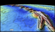
| This is the first altimeter in 15 years to map the global marine gravity field at such a high spatial resolution.
ИсточникиОписание: http://www.wikipedia.org/wiki/Криосат-2, http://www.ria.ru/science/20120528/659355789.html Изображения: ESA / AOES Medialab, http://www.esa.int, http://www.bbc.co.uk/news/science-environment-12025283 |


