Platforms: TOPEX/POSEIDON
From
Launched in 1992, TOPEX/Poseidon is a joint venture between CNES and NASA that measured ocean surface topography to an accuracy of 4.2 cm, enabled scientists to forecast the 1997-1998 El Nino, and improved understanding of ocean circulation and its effect of global climate. While a 3-year prime mission was planned, with a 5-year store of expendables, TOPEX/Poseidon delivered an astonishing 13+ years of data from orbit. The mission ended in January 2006.
Objectives
- Three-year global view of Earth's oceans
- Improved understanding of ocean currents
- Improved forecasting of global climate
Mission
- Joint NASA-CNES program
- Launched August 10, 1992
- Launch Vehicle: Arianespace's Ariane 42P
- Launch Site: Centre Spatial Guyanais, Kourou, French Guiana
- Operations for 3-year prime mission, 6-year extended: JPL
- Orbit: 1336-km, circular, 66° inclination
- 10-day repeat of ground track (±1-km accuracy)
- Covers 95% of ice-free oceans every 10-days
Spacecraft
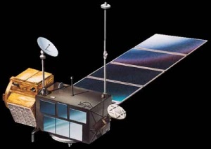
- Based on Fairchild's Multi-Mission Spacecraft bus
- Total mass: 2402 kg (5296 lbs)
- Single solar panel provides 3.4 kW of power
- 1.2 m (4 foot) high-gain antenna communicates through TDRSS
- Reaction wheels and torque rods maintain 3-axis stabilization and nadir pointing
- Hydrazine propellant system provides orbital maintenance
Payload/Sensors
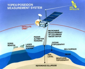
- NASA dual-frequency (C- and Ku-band) altimeter and CNES single-frequency (Ku-band) solid-state altimeter measures height above sea
- NASA microwave radiometer measures water vapor along altimeter path to correct for pulse delay
- NASA Global Positioning System demonstration receiver provides precise orbit ephemeris data
- NASA laser retroreflector array works with ground stations to track satellite and calibrate and verify altimeter measurements.
- CNES DORIS Doppler tracking antenna receives ground signals for precise orbit determination, satellite tracking, and ionospheric correction data for CNES altimeter
Data
- Sea-level measurement accuracy 4.2 cm (1.7 inch)
- Data coverage global between 66°N and 66°S latitude
- Data availability through NASA/JPL and CNES
Спутник
|
In those 13 years, it:
|
Результат
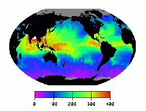
| This plot shows the mean wet troposphere correction during cycle 30 of the Topex/Poseidon mission, i.e. during the 10-day interval starting 7 July 1993. The mean correction during this time period was 156 mm, the maximum 454 mm, the minimum 0 mm. | |
Источники
Описание: http://sealevel.jpl.nasa.gov/missions/topex/
Изображения: http://space.skyrocket.de/doc_sdat/topex-poseidon.htm, http://iliad.gsfc.nasa.gov/opf/algorithms/wet_topex.html, http://en.wikipedia.org/wiki/TOPEX/Poseidon


