Platforms: TOPEX/POSEIDON
From
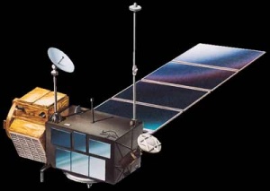
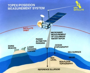
Launched in 1992, TOPEX/Poseidon is a joint venture between CNES and NASA that measured ocean surface topography to an accuracy of 4.2 cm, enabled scientists to forecast the 1997-1998 El Nino, and improved understanding of ocean circulation and its effect of global climate. While a 3-year prime mission was planned, with a 5-year store of expendables, TOPEX/Poseidon delivered an astonishing 13+ years of data from orbit. The mission ended in January 2006.
In those 13 years, it:
- Measured sea levels with unprecedented accuracy to better than 5 cm
- Continuously observed global ocean topography
- Monitored effects of currents on global climate change and produced the first global views of seasonal changes of currents
- Monitored large-scale ocean features like Rossby and Kelvin waves and studied such phenomena as El Nino, La Nina, and the Pacific Decadal Oscillation
- Mapped basin-wide current variations and provided global data to validate models of ocean circulation
- Mapped year-to-year changes in heat stored in the upper ocean
- Produced the most accurate global maps of tides ever
- Improved our knowledge of Earth's gravity field
Спутник
|
Objectives
Mission
Spacecraft
Payload/Sensors
Data
|
Результат
|
File:Wet.jpg
300px
|
This plot shows the mean wet troposphere correction during cycle 30 of the Topex/Poseidon mission, i.e. during the 10-day interval starting 7 July 1993. The mean correction during this time period was 156 mm, the maximum 454 mm, the minimum 0 mm. |
Источники
Описание: http://sealevel.jpl.nasa.gov/missions/topex/
Изображения: http://space.skyrocket.de/doc_sdat/topex-poseidon.htm, http://iliad.gsfc.nasa.gov/opf/algorithms/wet_topex.html, http://en.wikipedia.org/wiki/TOPEX/Poseidon


